By:
Submission
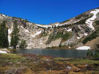
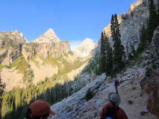
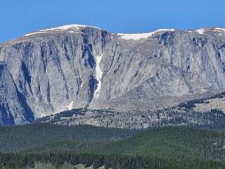
This strenuous 19 mile loop takes you up Paintbrush Canyon, over Paintbrush Divide to Lake Solitude, and back out Cascade Canyon. The trail offers some of the most spectacular views in the park, with the 10,700ft Paintbrush Divide offering panoramic views of Mount Moran, Mount Woodring, and Rockchuck Peak. From Lake Solitude, hikers have a direct view of the Grand Teton and Mount Owen. Hikers should plan on a full day to hike the loop. Before attempting the loop, stop by the Jenny Lake Ranger Station to speak with a ranger about conditions on Paintbrush Divide, as the divide often holds snow until mid-July and can be dangerous if attempted without the proper snow equipment.
Paintbrush Canyon-Cascade Canyon is a strenuous 19 mile (30.6 km) loop trail, with 4350ft elevation gain. Trail obstacles include bridge crossings, steps, exposed roots and rocks, and steep switchbacks. Trail crosses a skree field that holds snow late in the year.
$45 for advanced reservations, booked through Recreation.gov
$35 for walk-in permits
Requests for advance reservations are only accepted beginning January 6, 2021 through May 15, 2021. All reservations are processed through Recreation.gov in real-time. To facilitate your reservation experience, please establish an account on Recreation.gov prior to the advance reservation season.
A non-refundable service fee of $45 will be charged for each reservation (fee is per trip, not per person). One-third of the sites are reserved in advance, leaving two-thirds available for walk-in permits. Walk-in permits will be assessed a $35 fee per trip.
Some camping zones fill quickly. Download the backcountry trip planner to review regulations and a map showing the authorized camping zones. Individual party reservations can consist of up to six people. Groups of 7-12 people must camp in designated group sites indicated on the brochure map. View maps of the backcountry camping zones.


This is an amazing hike to do up Paintbrush Canyon and over the divide looking across into Idaho and going down Cascade Canyon

This was the highest point, alongside Hurricane Pass in our 4-day backpacking trip from Death Canyon Trailhead to String Lake Trailhead. If you're coming from String Lake, there will be a 3000 ft climb over 9 miles to get to the divide. The views are gorgeous and there are multiple little protrusions from the main trail. They're all worth checking out. Going counter clockwise, this is a 1500 ft climb from Lake Solitude. It can get bit windy and chilly at the top.

Elevation up here is manageable and the views down to two different canyons can’t be beat. The rocky solitude of this ascent is mystical, as one attempts to understand the sheer magnitude of these grand tétons. Hiking up to this summit from Paintbrush Canyon will be one of the most memorable hikes in my life.

It's only 10,700 ft high divide but it offers grand views and some exciting twist-n-turn along the trail on the mountain face. Enjoyed it very much!

Awesome…difficult. Completely snow covered in June on the north side. Needed spikes and didn’t have them. Had to hike over deep drifts, with part of the trail gone due to a small avalanche. Inexperienced so I didn’t know if I should go above or below, decided to go above, challenging, it was a long way down. After crossing I think going below would have been safer. I took two days, but met some hikers doing it in one. 22 miles and 4200 elevation gain according to the map. I rate it difficult.